
I have a secret: for some reason, Canyonlands was never really on our top to-visit list! Sooo sad, right?! Well, now we've been and it's once of my absolute favorite parks! Since we have 4WD, we were able to snag a permit to drive the White Rim Road and it was one of the coolest experiences I've had. Keep reading for the low down on the park and what to do while you're there!
ABOUT CANYONLANDS
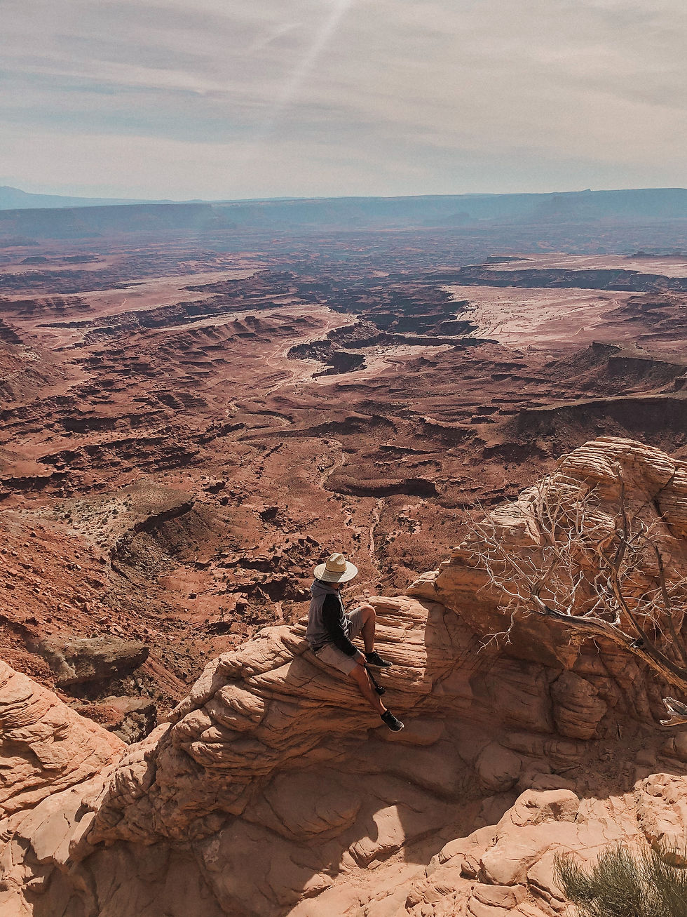
Canyonlands is one of the fab five parks in Utah and is situated just outside of Moab, next to Dead Horse State Point Park and about an hour across the way from Arches National Park. The ENTIRE area is jaw-dropping, even before you enter the park! One of the best areas in Utah to explore for sure. The park itself is HUUUUGE at a whopping 337,598 acres. It's so freaking big that it's split into five different districts: The Maze, the Island in the Sky, The Rivers and the Needles, Canyonlands. Island in the Sky: This area is the closest to Moab and often the busiest since. I feel like it's the most visitor-friendly since it's jam-packed with short hikes and stunning overlooks. The Needles: This section features super unique sandstone rock formations and some rad, yet longer, hikes. It does take longer to get here from Moab at a 1.5-hour drive. If you have an extra day at the parks, you should definitely check this area out!
The Maze: This is a more remote area that you can only access with a 4X4. You definitely need the outdoor experience to explore this part of the park. Be sure to notify someone you're going here before you head in!
The Rivers: The Colorado and Green Rivers have are exactly how Canyonlands came to be! They are the rivers that have created the gorgeous canyons you see throughout the entire park, but in this district, you can canoe or kayak the rivers north of the Confluence. You can also go white water rafting in Cataract Canyon!


THINGS TO DO
Mesa Arch
I will forever remember this as the Arch where I tripped and ate it... right in front of the arch, too. It's probably one of the busiest places in Canyonlands, so we recommend getting there early to beat the crowd. It's about a .05 mile hike and involves some scrambling over rocks but is relatively easy.
This arch truly is spectacular in person! I feel like that was crazier was the drop-off and magnificent view behind it. It's particularly stunning at sunset or at sunrise if you want to get a good snap!

Grandview Point After Mesa Arch, keep driving just a little bit longer down Grand View Point Road to another super poppin' spot that is a quick visit. You can just take the short walk to the viewpoint or take one Grand View Point Hike for a 2-mile round trip hike (about 2 hours).

Aztec Butte Hike This trail is such a fun one! It's 1.7 miles out and back that crosses the level grasslands and then climbs a steep slope up the dome-shaped butte rising above the mesa. It definitely involves climbing/scrambling up rock, so make sure you wear your good hiking boots. I loved this hike because there was so much history on it! Alcove along the rim of the butte feature Puebloan granaries that early inhabitants used for food storage. The top of the butte visits two of these granaries and gives you awesome views of Taylor Canyon. When you come back down, there's a small spur trail that goes off for about 0.8 miles and involves a much easier scramble. You'll walk on top of the mesa and then walk down the side to catch another granary. This one was the coolest in my opinion! We sat there imagining what life was like when they used these.


White Rim Road + Schafer's Trail You may be wondering, what the heck is the White Rim Road and why is it such a big deal? Well, it's only a 100-mile road that is literally the "rim" of the insane canyons in the Island of The Sky district... and you can DRIVE it! You'll descent from the Island in the Sky mesa down Schafer Trail to the next layer of rock and get views of canyons above and below you that stretch on farther than the eye can see. It feels like you're in an entirely different world!
First thing's first, you need a FREE permit to drive the roadwhich you can read more about + find HERE. There are permits for day trips or for camping/overlanding. Many people pop in for a day to drive a portion of the road (like us!) or spend a few days overlanding to drive the full 100 miles. Make sure you try to snag camping ones ahead of time - they fill up fast.
You also need a high clearance, 4WD vehicle. PLEASE do not attempt to drive this road without one - you'll get stuck for sure. We drove in our FJ Cruiser and had an awesome time. If you don't have a car equipped for the road, you can actually rent a jeep or even take an excursion through some private companies on the road.
Third, COME PREPARED. That means a full tank of gas (and even jerry cans of gas), plenty of water, snacks, a map and even some extra clothes or a blanket even if you're only doing a day trip. We always recommend being more prepared than you need to be, especially when visiting places that are more desolate. We also love using onX Offroad App for all of our offroad and hiking trails - you can download the maps and use it offline. Conditions vary on this road with spring and fall being the most popular time to visit. We went the first week of October and it was perfect - still warm but not scorching.
Schafer Trail. One of my favorite parts of the trail and what looks like the most intimidating! To get to the White Rim Road, you can enter here or through another road by the Potash Ponds, but I personally think this one is more fun. You might wig out a little when you first see/drive onto Schafer since it's a narrow dirt road complete with sharp switchbacks and a nice incline down into the canyon, but it's SO fun. The road is maintained, in really good condition and there are plenty of places where two cars can pass each other going up & down the road. As soon as you make it down this portion, the trail straightens out and you can either go left towards Potash or right and start your journey in the White Rim Road
Sights to See: Take the 0.6 mile hike to Gooseneck Overlook for an insane view of the bend of the Colorado River. Directly after that, look for the sign and small lot for Mussleman Arch. It's a quick walk and so cool to see - keep an eye out down to your right since it can blend into the canyon easily. Our last stop was the steep drive down into Lathrop Canyon that spit us out at some picnic tables and next to the river. The drive down was insane and felt like we were in Jurassic Park or something as drove through some narrower canyons.


Schafer Canyon Viewpoint If you aren't into driving down the thrilling road of Schafer's Trail, you can take in the views and watch others do it! At this small turnout, you can park and walk up to the rim of the canyon overlooking the switchbacks of the trail that extend down to White Rim Road. It's so cool to watch all the cars go up and down. I parked it here and got some shots of Nathan going up and down, too!


Bonus: Sunset at Dead Horse Point State Park If you're ending the day out near the park, you definitely want to drive into this park and check out the views here at Sunset! You get an awesome view of Canyonlands and the Potash Ponds. Keep in mind, Dead Horse Point State Park has a separate admission fee of $20 for a car up to 8 peeps.

PHEW. I know that was a long post, but I had so much to share about White Rim Road and Canyonlands! If you have any more questions about Canyonlands, shoot me a DM on IG!
Comments